Well San Diego is almost here! My first trail 100 miler and I have never been on a mile of the trail. I went to UCSD long ago but never venture beyond the coast for the most part.
June 9-10 2012
This race is east of San Diego and is on parts of the PCT. It looks like it is various loops in the mountains with altitude from 3000 to 6000 feet. Course Maps
HERE.
The goal for me is to make the 32 hour cutoff so that I can get a Western States qualifier.
For this race, I am using drop bags for the first time and hopefully I am planning right. It is Thursday morning and I am in my room trying to guess what I will need at the four drop bag locations.
Right now I am going with a bottle of Dr. Pepper, a peanut butter and honey sandwich,
Clif Shot Blocks and
Saltsick caps.
For on the run hydration, I am in a quandary. For years I have used a
Nathan pack and one
Nathan handheld but often I do not empty the backpack and hence I care a lot of extra food and water during the race. So at the Leona Divide 50 miler, I went with 2 handhelds like the fast runners do and it went well except that my arms got tired at times. I did not run out of water during the race and liked not wearing a backpack.
But for this race, I do not know the course or how long it will take me to get from point to point. Hence my dilemma.I do not want to wear my Nathan but I do not want to run out of fluids. Another issue is that my Nathan seems to chafe me and I would rather not deal with that problem.
One solution is to use my day hiking
Camelbak which I really like despite it's size. I have summited Whitney twice with this pack and done the R2R2R twice with it as well. It holds 100 ounces instead of 70 ounces which is good but means more weight. The nice think about my Camelbak is that it doesn't chafe and is really comfortable.
If i go with the Camelbak, then I could use
Black Diamond Ultra Z - Poles which worked great at the Grand Canyon. The SD 100 allows poles and the BDUZs are so light, it would be worth it to use them.
A friend (Jason) sent me this report of the course:
- 0-13.8 miles: Very runnable so don't overdue it.
- 13.8 - 23.6 miles: Some mild climbing and descents
- 23.6 - 31.3 miles: Tech descent, loose rock, hard on the ankles, hot and exposed.
-
31.3 - 36 miles: 4.7 mile loop: Hot, persistant horse flies. They draw
blood. Brind bug spray or a face net. tougher than it looks.
- 36 - 44.1 miles: 8 mile climb in the exposed heat. 1/2 paved service road, 1/2 trail. Bring fuel and plenty of water.
-
44.1-51.3 miles: It might be dark by now. May people Drop at mile 44.1.
I believe they when out to fast in the first 23 and didn't take care of
them selvesin the canyon and during the climb. Make sure to have a
flashlight through here. It rolls and has the best views of the run plus
thousand foot drops.
- 51.3-58.9 miles: rolls and flattens out up to stonewall mine.
-
58.9 - 64.2 miles: rolls to flat before heading up a steep climb. Very
exhausting climb. By this time, it was midnight for me. The wind picked
up and the temps dropped a lot. The lows reached down into the low 30's
so be prepared for that. After reaching the top, you have a tech decent
to paso picahio.
- 64.2 -72.3: mild steady climb then a downhill rolling trail to sweetwater.
- 72.3 - 80.3: flat with a few mile climb up to sunset. The sun was rising for me as I approached sunset.
- 80.3 - 87.5: Rolls up to Pioneer mail 2. If the sun is up, it will start to heat up fast. Great views
- 87.5 - 91.5: Kind of loops around and is generally an easy section.
-
91.5-96.2: Felt like the longest 4 miles of climbing ever. Exposed and
the last thing I wanted to see so near to the finish. You can get
through it.
- 96.2 - 100 Miles: rolling and flat to the finish.
The above was a preview of sorts and now it is Monday morning.
- San Diego 100 Mile Endurance Run - Coyote Style! (Photos by Alison HERE.)
- My first 47 miles HERE.
- Next 19 Miles HERE.
- Official Race Photos HERE.
- The winner's race report HERE.
 |
| The view from race HQ on Friday was beautiful and intimidating at the same time because one could see what lay ahead for us the next day. |
I left Bakersfield around 7:30 am on Friday and headed to the race. On the way there I stopped at Tommie Burgers for a pre-race ritual chili burger and when I back on the road, the traffic was pretty bad until I got past Disneyland. Since I went to UCSD, I knew the route and expected the drive. What I did not realize was that the race was a good 90 minutes away from the coast.
 |
| View from start / finish area. |
 |
| View from my bunk. |
 |
| Start |
 |
| First mile following the Jester. |
 |
| Following Todd |
The above photos are from the start to the Meadows aid station. Todd and I were a team in that I followed him and only ran when he got 50 yards or more away. Todd was 70 and has run 30 hundred mile runs and lives in San Diego. So I figured he was the man to follow. He had run the race and knew the area well. Plus he had a plan to finish before the 32 hour cutoff.
- mile 1 - 1252 up 251 down 237
- mile 2 - 1341 up 63 down 137
- mile 3 - 1336 up 104 down 0
- mile 4 - 1433 up 142 down 27
- mile 5 - 1644 up 186 down 252
- mile 6 - 1621 up 46 down 244
- mile 7 - 1539 up 227 down 79
- mile 8 - 1423 up 21 down 153
After we left the first aid station, we did not see any other runners for awhile. The trail was still really nice and so were the views. But soon we started climbing and the trail got dryer.
- mile 9 - 1621 up 207 down 0
- mile 10 - 1548 up 145 down 153
- mile 11 - 1451 up 30 down 137
- mile 12 - 1703 up 295 down 0
- mile 13 - 1737 up 230 down 0
At the Red Tail Roost AS (13.8) we found out that we were not last after all. Our overall pace was consistent and Todd said we were ahead of his planned 32 hour pace. The next aid station was Todd's Cabin (18.6) and I was running with Todd!
- mile 14 - 1449 up 54 down 154
- mile 15 - 1538 up 222 down 106
- mile 16 - 1442 up 43 down 255
- mile 17 - 1705 up 241 down 74
- mile 18 - 1643 up 140 down 132
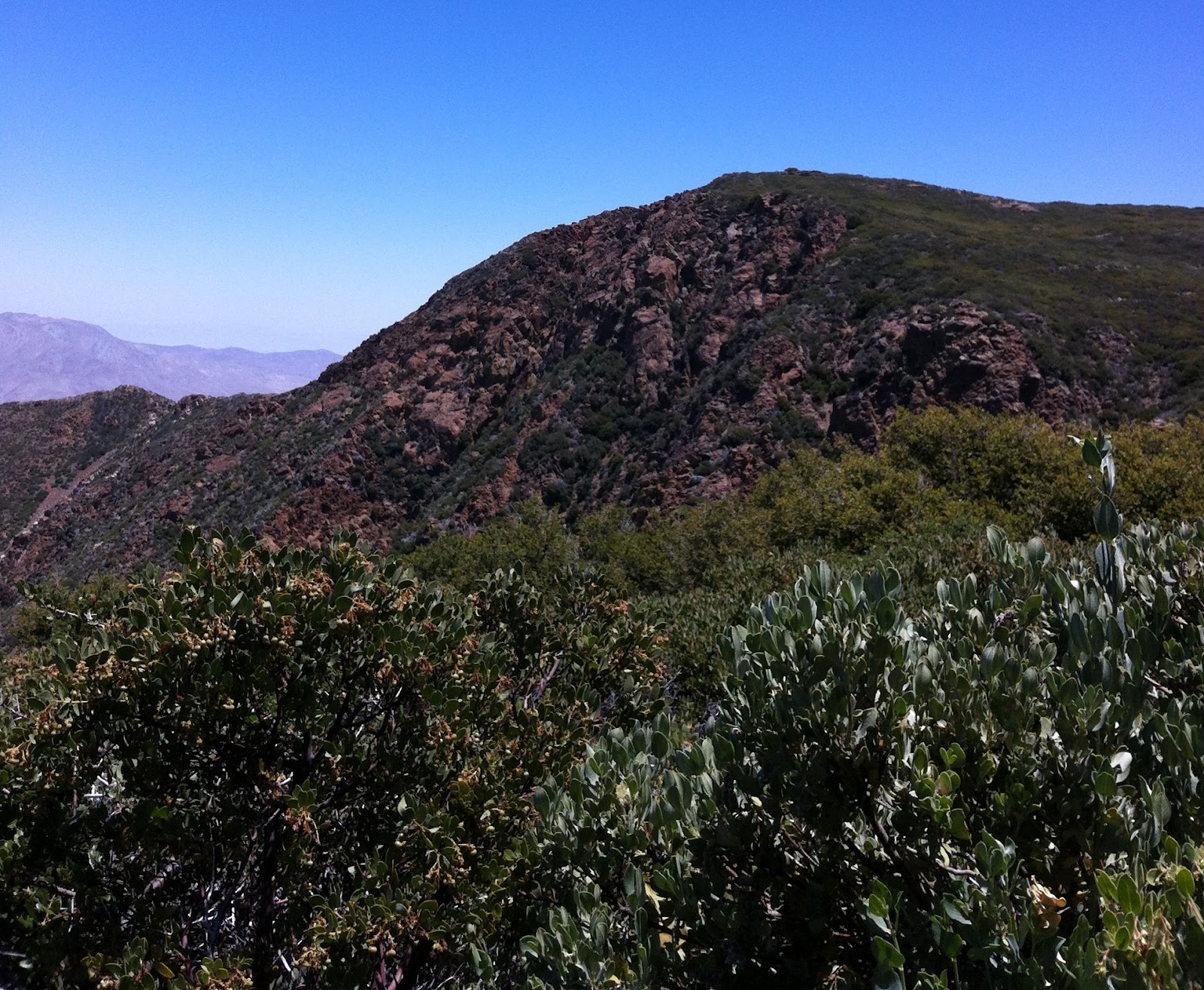
After we left Red Tail Roost (13.8) we were on a fire road for awhile and then rejoined the PCT. As you can see it was warmer and rockier. With the footing being more difficult, I was concerned about tripping and about a mile from Todd's Cabin, Todd went down pretty hard.
 |
| Todd headed to his cabin. |
Todd's Cabin was right off the PCT but we had to go down a hill to get to it. While descending the short hill we ran into a couple Coyotes plus there were one or two runners at the aid station.I had concerns that when Todd got to his cabin that he might stay awhile and he did. His wife was taking care of him when I left. I hope that his earlier fall did not hurt him much.
 |
| Pedro |
 |
| Erin |
As I left Todd's Cabin (18.6), I hoped to maybe catch the two coyotes but they were long gone and I was on my own. Just after I past a large group of Boy Scouts, I tripped and fell for the only time in the race. It was not a hard fall but I did drop the banana that I hoped to eat.
For the next 5 miles I tried to catch the coyotes but they were moving. As we near the start area, I heard people howling and yelling and looked over to the start area and saw the coyotes running through the tunnel of love. I was jealous but it was nice to hear and see some people. So I hit my watch to find out how far ahead they were to me.
As I approached the area that the tunnel of love had been at, I saw that everyone had left. I was about 8 minutes behind but I might as well have been on the other side of the moon. So I kept moving to the Penny Pines AS (23.6) which was captained by Nanny Goat RD Steve Harvey.
- mile 19 - 1821 up 69 down 175
- mile 20 - 1652 up 207 down 71
- mile 21 - 1501 up 60 down 328
- mile 22 - 1459 up 99 down 257
- mile 23 - 1647 up 126 down 287
- mile 24 - 1922 up 147 down 91
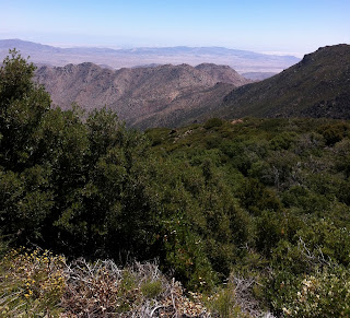
As I left the aid station, Todd came in and he was the last athlete I would see till mile 31. To get to mile 31, we had to descend Noble Canyon which was fairly steep and rocky on the upper part. Then it dropped into a wooded section and followed a creek to a valley.
- mile 25 - 1800 up 132 down 229
- mile 26 - 1715 up 117 down 191
- mile 27 - 1625 up 0 down 308
- mile 28 - 1736 up 66 down 353
- mile 29 - 2129 up 17 down 591
- mile 30 - 1802 up 25 down 159
- mile 31 - 1651 up 58 down 159
The winner of the race (
Jeff Browning aka Bronco Billy) said of this section:
Heading down from Penny Pines into Noble Canyon, I took it easy and
stopped at the few small stream crossings and dipped my hat. On the
lower section of this descent, it’s really technical and I ran up on
some downhill mountain bikers all decked out in full faced helmets. We
leapfrogged a couple of times and finally I dropped them and soon
arrived at Pine Creek aid (mile 30) and was really feeling the heat.
So I don't feel so bad taking my time going down Noble.
 |
| The trail down Noble Canyon. |
 |
| Aid Station Valley |
At the valley I made it to the Coyote aid station and was glad to see Alison (the unicorn) and the rest of the crew. This AS was busy because it was also the 36 mile aid station. Unfortunately they were out of sports drink and ice.
 |
| Ed |
 |
| Wearing five fingers |
This section was described as a lollipop loop but they left out how fugly it was. As I headed out, everyone I saw looked beat and I asked a few what was out there but no one said a thing.
As I past the Coyote trail guide, I realized that we were going up and around the hill to her right. It was an unexpected ascent and descent that few expected.
- mile 32 - 1721 up 80 down 360
- mile 33 - 2038 up 169 down 68
- mile 34 - 2144 up 394 down 0
- mile 35- 1551 up 0 down 292
- mile 36 - 1657 up 44 down 148
 |
| The infamous steep road. |
What was expected we miles 36 to 44. We all heard about "The Climb" and how hot it was going to be. One good thing about being slow is I went up the hill at 5pm and the temperature was not an issue. Before I left, lead Coyote Jimmy told me I had less than 3 hours to make it to the AS and that many in front of me had taken much long. Plus the RD Scotty was there and I told him I was going to make it (I was the last to leave the AS btw.)
 |
| Barely a trail. |
 |
| Barely a trail. |
I made good time up the hill and was glad I caught the Popsicle man before he left. When the trail finally leveled off, I finally saw another athlete.It was mile 42 or so and I had not run with anyone since mile 18. He came back to life and we ran to the 44 AS where it was getting dark and was super windy.
- mile 37 - 1933 up 304 down 33
- mile 38 - 1927 up 404 down 0
- mile 39 - 2154 up 333 down 147
- mile 40 - 1924 up 150 down 210
- mile 41 - 2330 up 498 down 0
- mile 42 - 2025 up 378 down 0
- mile 43 - 1508 up 82 down 91
- mile 44 - 1415 up 0 down 208
Unfortunately his family was at the AS and he dropped out. I grabbed food and drinks and my headlamp and headed out with 23 minutes left on the clock. I think the AS workers expected me to drop but I was going to go till I was pulled from the race. This section overlooked the desert and was really windy and was uphill too.
From time to time I saw a headlamp and eventually I caught one or too of them. At this point my Garmin battery had died so I had no idea what my pace or distance was. I knew I had to 10pm to get to Alison at the AS so until that time, I kept going forward.
- mile 45 - 1508 up 202 down 0
- mile 46 - 1646 up 60 down 74
- Garning battery died.
As I got closer, i went around a blind turn and almost ran into the leader of the race who was at 80 plus miles. He was moving so fast that he was gone in a flash. Then when the wind and dark almost got the best of me, I finally saw the 51 mile AS. It was lite up with music and was a welcome sight.
As I was running in to the station I had a kangaroo mouse running ahead of me for the last 100 yards. He seemed to be stunned my headlamp. When I got to the AS, Alison was there with my camelbak and poles. I only had 15 minutes to spare with regards to the cutoff. So I grabbed a burger and a grilled cheese and headed back on the trail.
- Sunrise (51.3) to Stonewall Mine (58.9) up 582 down 827
- mile 52 - 1651
- mile 53 - 1720
- mile 54 - 1826
- mile 55 - 1809
- mile 56 - 1719
- mile 57 - 1621
- mile 58 - 2005
- mile 59 - 1822
 |
| Miles 52 to 59 is 0 to mile 8 on graph. |
On the trail to the next AS it was getting cold and still really windy. This section was flat for awhile but kind of confusing and we got lost a few times (briefly). We caught a few athletes on this section which was good so we didnt go off the course too much. When we made the next AS, I was 30 minutes up on the cutoff.
At the Stonewell Mine AS (58.9) we caught a few athletes and then headed off to the Paseo Picacho AS (64.2) which had some difficult ups and downs (1217 / - 1046). When I got to the AS, I was still up 30 ,minutes on the cutoff but I was feeling good and hoped to make it to the next AS at 72 miles.
- Stonewall Mine (58.9) to Paso Picacho (64.2) up 1217 down 1046
- mile 60 - 2125
- mile 61 - 2607
- mile 62 - 2357
- mile 63 - 1939
- mile 64 - 1956
 |
| MIle 60 to 64 are miles 9 to 13 on the graph. |
We left at 2am for the next 8.1 mile section which turned out to be very rocky with a lot of descents (1549 / -2314). it was really cold out there as well and when the sweeper caught us (again btw) we found out we had a couple more miles to go and it was almost 5am. so I decided with the trail flattening and some light out that I would make an effort to get to the next AS before the cutoff.
- mile 65 - 3304
- mile 66 - 2735
- mile 67 - 3441
- mile 68 - 2502
- mile 69 - 1935
- mile 70 - 1603
So I put in sub ten minute mile pace and raced to the AS that I finally saw up ahead. To get to it, I had to run through a creek and then up a slight hill. As I ran into the AS, my watch said 5:25am and I thought I made the cutoff but everyone was oddly quiet and just staring at me. The the AS captain informed me the cutoff was 5am.
I checked my course sheet and found out that it was 5am and my day was done. So I had some soup and waited for a ride back to mile 80. As we waited, we found out how cold it was. They were washing the tables and the water was freezing on them! After they broke down the AS, we got a ride back to Alison's car at mile 80. On the ride over, I found out that a 50 mile horse race and a 25 mile ride and tie had been run on the last 8 mile section that was the end of my dream of finishing. No wonder the trail seemed so beat up.
The
winner of the race said this about this section:
It was my kind of technical, narrow, rocky singletrack descent and the
music was good on my iPod and I just got in a rhythm here and flowed.
Before I knew it, I arrived into Sweetwater (mile 72) at 6:23pm — almost
an hour faster than CR splits.
So again his words made me feel a little better.
When we got to the 80 AS it was kind of sad because I know I would have made it in 2:30 (for 8 miles) the trail was good and either uphill or flat the whole way there. After 80 miles the course is basically like the first 20 miles of the course and so I would have finished under 32 hours but rules are rules.
When I got back to the start / finish area, I took a quick cold shower and then decided to drive home asap. I saw the RD and he gave me a big hug and said I really did well. One of the sweepers said the same thing as well. Then it was time to face my 5 hour plus drive home.
Too be continued ...

 The goal for me is to make the 32 hour cutoff so that I can get a Western States qualifier.


 After we left the first aid station, we did not see any other runners for awhile. The trail was still really nice and so were the views. But soon we started climbing and the trail got dryer.


 For the next 5 miles I tried to catch the coyotes but they were moving. As we near the start area, I heard people howling and yelling and looked over to the start area and saw the coyotes running through the tunnel of love. I was jealous but it was nice to hear and see some people. So I hit my watch to find out how far ahead they were to me.
  As I left the aid station, Todd came in and he was the last athlete I would see till mile 31. To get to mile 31, we had to descend Noble Canyon which was fairly steep and rocky on the upper part. Then it dropped into a wooded section and followed a creek to a valley.


 This section was described as a lollipop loop but they left out how fugly it was. As I headed out, everyone I saw looked beat and I asked a few what was out there but no one said a thing.
 As I past the Coyote trail guide, I realized that we were going up and around the hill to her right. It was an unexpected ascent and descent that few expected.


 I made good time up the hill and was glad I caught the Popsicle man before he left. When the trail finally leveled off, I finally saw another athlete.It was mile 42 or so and I had not run with anyone since mile 18. He came back to life and we ran to the 44 AS where it was getting dark and was super windy.

 Unfortunately his family was at the AS and he dropped out. I grabbed food and drinks and my headlamp and headed out with 23 minutes left on the clock. I think the AS workers expected me to drop but I was going to go till I was pulled from the race. This section overlooked the desert and was really windy and was uphill too.